So after some unexpectedly painless early miles on Sunday's attempted start of the remainder of the UK Circumnavigation, my knee sent me a message that I was a bit premature in trying to get going. It pretty much seized up just after stopping to take a photo of Southend Pier. That was 40 miles in.
 |
| Route completed so far - Hope Cove to Southend - Not exact route, but a good representation |
I accepted defeat and bought a train ticket home, thinking that for optimism and sanities sake I should get an open return. This gives me a month for recovery and to get back to Southend with bike and gear.
Doctor Tuesday morning, referred me to a physiotherapist, though annoyingly over a week away. Doc mentioned that my lower leg might bow outwards slightly more than other peoples, meaning that ligaments and tendons might be moving over more prominent bones than they would in normal people, meaning more friction, inflammation and subsequent pain. This makes sense with regard to the type of injury it seems to be, (Iliotibial band syndrome - Tract up the outside of your leg - lower knee to hip, that exists to give lateral stability to the knee)
Overall, it's annoying! Just an anatomical issue, which I can't really get around. Oh well!
Now that I have had to (hopefully) delay and return home from Southend, I am contemplating what I can do to fill this time void, previously to be filled with pedalling. I am in recovery mode now, dosing myself up with Ibuprofen and applying anti-inflammatory gel intermittently. I am going to give it one week of full rest, no activity, in which time hopefully I shall get a physio appointment.
I was going to write this - [Then I am going to consider climbing and slacklining again. This will coincide nicely with my brother returning me my climbing gear and my slackline. Climbing I am sure will not stress the ITB and I need to be active some way and slacklining, I hope will just aid with conditioning. We shall see!] But then saw this - ACTIVITIES I CANNOT DO WHILST RECOVERING FROM ITB SYNDROME.
Sports activities to avoid while symptomatic
Enough of the negative - here are some photo/images of what I have already experienced in the 500 miles of what I have achieved so far on the circumnavigation of the UK.
 |
| Getting used to my Garmin which is superb piece of kit I run off solar power. I can record all the details of a day on it, as you can see down the left hand side. As well as knowing exactly where I have gone. Tough days like my first (above) on the undulating coast of South Devon. 1,614m of altitude gain is the equivalent of cycling up Ben Nevis and then some. Can see by 188 beats per minutes max heart rate how difficult some of those hills are! |
 |
| Torcross - Slapton - Bank of shingle protecting a cut off freshwater lake, supporting much wildlife, particularly the winged kind. A beautiful part of the world, a place I have visited much and a really nice part of first day ride. Nice and flat for a few miles before that coast in the background towards Dartmouth really ramps up. |
 |
| Dartmouth Castle - Kingswear Castle across the river mouth. Used to string a chain between the two castles, to prevent enemy ships entering the then very influential shipping Port. |
 |
First Ferry Crossing - Only here did it
feel like I was actually starting the trip |
 |
| Ferry to Kingswear |
 |
| Shaldon looking over at Teignmouth |
 |
Another Ferry crossing from Starcross to Exmouth,
avoiding a long detour into Exeter |
 |
| One of the most spectacular views I have EVER seen - no exaggeration!!! |
 |
| Start of Jurassic coast East of Sidmouth |
 |
| First night's camp just outside.... |
 |
| Lyme Regis harbour |
 |
| Amazing cliff 'Golden Cap' so named for prominent shape and shade of sandstone - highest cliff point on the entire South Coast of UK at 191 metres |
 |
| You can see just how high golden cap is here. On a good day, you can see Dartmoor and top of the picture, all the way down to the end of Chesil Beach. Was my first foray away from the bike. I took my road bike off road for a couple of miles to get to the base of the 'cap' without puncturing, then gave my feet some fresh air. It was wet, so a really nice climb! |
 |
| Who's that Pillock?! |
 |
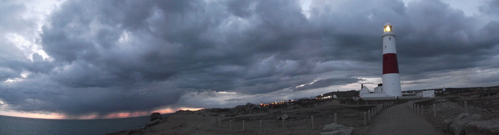
| Portland Sunset, Rainstorm at Sea - superb view. End of a long day, heading out to Portland Bill, best time to get a good ol' puncture is twilight. 4 miles off road earlier in the day and you puncture on the road. One of those evenings, as I also thought that two pieces of my equipment, including my navigation (Garmin) had failed. Luckily was still in good spirits post puncture and enjoyed heading out to the Lighthouse under the ominous skies. See below |
 |
| Portland Bill - Beautiful moments... These storm clouds were rolling across the coastline for miles. I felt like I was the only person on the South coast out of the firing line as the storm passed along the mainland coast, leaving the tip of Portland with clear skies above. |
 |
| 2nd night - poor horses. I woke with a start in the early hours and frightened the hell out of that pair, who took flight. 8 o clock a lady parked across the road, came down, opened the gate, fed the horses and left. I said hello, she said hello, completely nonplussed by my presence. So refreshing! |
 |
| Top of image - Sleeping within spitting distance of ol' Bill. A highlight of the trip so far!!! Like this photo! |
 |
| Met some cyclists in Wareham after passing the Saxon walled city defences, (now grassy mounds surrounding the city) .Garmin not working, they suggested a route down to Corfe castle where I could then get onto the Studland peninsula road, taking me all the way to the toll ferry,across to Sandbanks |
 |
| Studland Peninsula. Amazing place! A cross between the new forest and the Gower peninsula. Felt like I was in Spain on checking out the beach. |
 |
| After the long stretch along the promenade from Poole to ferry crossing at Mudeford, (totally flat riding), and from there, east to Lymington, I turned north into The New Forest, through Beaulieu, with the intention of staying at a friend Hannah's house in central Southampton. Nothing like a last minute phone call for a request to stay the night! Through The New Forest, take the advice of anyone suggesting that you stop at Bucklers Hard. A bit of a surreal place, but all the better for it. |
 |
| Portchester Castle - Amazing ruins |
 |
| Bosham - pronounced 'Bozzam'. I don't think I quite checked it out as I should have, but still appreciated the amazing little village. I continued my way round the Chichester harbour on a bit of a nostalgia trip, having spent much time down here, my dad being a frequenter of Chichester yacht club. I miss estuary mud! Got stuck in it when I was a toddler on an investigatory mission. Turns out, even Red wellies and bow legs can't help you from getting stuck in that shit!!! |
 |
| Brighton's dead pier |
 |
| the Alive one |
 |
| Left Brighton on the morning of the Brighton marathon. A bit hectic but a cool experience! |
More days of riding the flat part of UK's coast. The original intention of the trip was to get to know the UK better. I have already learnt a major truth that I was unaware of. Much of our coastline is flat. Having grown up spending much time in the west country I had grown used to the steep undulating nature of the South West coast of the UK. I suppose I just assumed the rest of the UK was the same, without really thinking. How wrong you can be!
From Lyme Regis east, generally speaking the UK's coastline is flat. I am told this is the case up to pretty much just below Yorkshire. Seems weird, a flat coastline, but when you understand the origins of the coastline, it is not so strange >
> I am reading a book by Nick Weston, (of BBC's 'Coast' fame). He explains how the english channel ocurred when the ice retreated off the North of the UK mainline. The weight of the ice that was once rested on the North of the UK was immense and after it's retreat, it lead to a see saw motion of the land that now makes up the British Isles. This resulted in the North rising and the South losing altitude. Along with the warming (which lead to the retreat of the ice), sea levels rose and so with these two combined, water started filling the lowlands [then created] between what we now know as Northern France and Southern England. This continued in from the tip of Cornwall, eastwards up into the North Sea. The final blow was the submerging of a land bridge that used to exist off East Anglia that is now known as 'Doggerland'. The name relates to the naming of sea or 'weather areas' that you will recognise from the shipping forcast. "Dogger, Fisher, German bight..." Cool to see what the land was like then.

So long way round of saying why much of the South coast and lower East coast is flat - the relatively low lying and flat landscape allowed the sea to cut us off from mainland europe. And the remaining coastline is not that much higher than sea level.
Anyway, more days of riding the flat coast took me into Kent and the White cliffs - an obvious exception to the flat coast comments above.
 |
| A bit of off road up to Beachy Head |
 |
| A nice scene in Hastings! Somewhere I've never been before but enjoyed! |
 |
| Awwwwwwwwww |

This part of the trip was lovely. Ruins at Winchelsea (above) followed by Rye below. Absolutely lovely parts of England worth a visit if ever in the area. Superb!
They were both parts of the confederation of Cinque
( pro - 'sink') ports. The main ports were Hastings, New Romney, Hythe, Dover and Sandwich. There were also 7 limbs towns and 2 'antient towns', Winchelsea and Rye as mentioned. >
"The five ports are supported by the two so-called "Antient Towns" of Rye and Winchelsea whose councils traditionally maintained defence contingents for the realm of England."
 |
| Rye gunnery level |
 |
| Unfortunately the wonderful locations couldn't help the fact that it rained on me and then froze overnight. Worst night outdoors I have ever had! It was pretty unsafe actually! Oh well, if you live, you learn huh? |
Then I had a bit of a mishap. Certainly an eventful few days! Coming up to a roundabout my front brake went with the wheel as I breaked and pulled clean out of it's mount. Scared the monkeys out of me and I went careering across a roundabout. Not great! Having lost the allen key bolt, I had to go searching in the next town. They are not the most common thing in the bicycling world. I was lucky!

 |
| View over water from Ramsgate |
 |
| Lovely Broadstairs |
 |
| After terrible freezing night, I had to stay in a room overnight in Margate. Just what was needed, cheap and easy accommodation and a good sleep! |
 |
| Whitstable Bakery - These ladies kept me company for half an hour whilst taking stock after a very wet morning. As long as it is warm enough, I don't half enjoy cycling in the wet. |
 |
| So when you decide to undertake something like this, where do you start? Small book is the pocket guide (to take with me), big one is the more comprehensive version of the same book, for reference purposes. 'THE MOST AMAZING PLACES ON BRITAIN'S COAST'. Straight to the point really! I went through the whole thing so as to order the pocket guide because annoyingly, it is in alphabetical order, not ordered geographically. It was worth doing to make sure I hadn't missed any places I might be interested in. Still, over 1000 places took quite some reading. |
 |
| Southend Pier - too bloody far out to take photos. Over a mile long, I mean honestly! |
I put the camera away and my knee had seized, so Southend station > back home for recovery. I can't wait to continue! These photos remind me just what you can experience in a trip like this. Pretty intensive!!!


